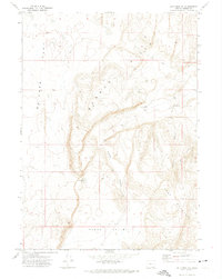
1971 Map of Acty Mountain NE
USGS Topo · Published 1974About this map
Basque Hills dominate the central landscape of this Harney County region, representing the stark, high-desert topography of southeastern Oregon during the early 1970s. The terrain is defined by dramatic drainage systems, most notably Funnel Canyon which carves through the elevations. This map is particularly valuable for its documentation of water sources in an arid environment, specifically locating Red Waterhole nestled in the western folds of the hills. Human presence is sparse, marked primarily by a network of Jeep Trails and specific landmarks like Prospect in the southeast corner. The transition between the high ridges and the broader plains of Butcher Flat and Hawks Valley illustrates the complex volcanic and erosional history that shaped this portion of the Oregon desert before modern developments significantly altered the primitive road networks.
Find a feature on this map
13 named features on this map. Tap any name to fly to it.
Don’t see what you’re looking for? This feature index may not catch every label — zoom into the map to look around manually.
Map Details
Editions of this 1971 Acty Mountain NE Map
This is the sole edition of this map. No revisions or reprints were ever made.
Other maps of this area

1955 · Adel
USGS Topo · 1:250,000

1957 · Adel
USGS Topo · 1:250,000

1958 · Adel
USGS Topo · 1:250,000

1962 · Adel
USGS Topo · 1:250,000

1971 · Square Mountain
USGS Topo · 1:24,000
1971 · Acty Mountain NW
USGS Topo · 1:24,000

1971 · Surveyors Lake
USGS Topo · 1:24,000

1971 · Coyote Gap SE
USGS Topo · 1:24,000
1971 · Hawks Mountain
USGS Topo · 1:24,000
1971 · Acty Mountain
USGS Topo · 1:24,000