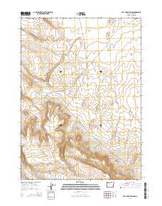
2014 Map of Acty Mountain NW
USGS Topo · Published 2014About this map
Water management and elevation define the high desert landscape of Harney County, where a series of essential catchments dot the terrain. Butch Reservoir, Gaston Reservoir, and Swede Reservoir provide vital water resources across this high-altitude range. The topography is anchored by the presence of Bald Mtn in the south and the level expanse of Butcher Flat to the northeast. Transportation through this part of the Oregon interior relies on isolated routes like Buckaroo Pass Rd and Nf-6176, which connect the high ground between the various drainage basins. Natural water sources like Seep Spring and the Shelby Reservoir further illustrate the geography of a region where every spring and reservoir is a critical landmark for navigation and land use.
Find a feature on this map
16 named features on this map. Tap any name to fly to it.
Don’t see what you’re looking for? This feature index may not catch every label — zoom into the map to look around manually.
Map Details
Editions of this 2014 Acty Mountain NW Map
This is the sole edition of this map. No revisions or reprints were ever made.
Other maps of this area

1955 · Adel
USGS Topo · 1:250,000

1957 · Adel
USGS Topo · 1:250,000

1958 · Adel
USGS Topo · 1:250,000

1962 · Adel
USGS Topo · 1:250,000
1971 · Acty Mountain NW
USGS Topo · 1:24,000

1971 · Surveyors Lake
USGS Topo · 1:24,000

1971 · Coyote Gap SE
USGS Topo · 1:24,000

1971 · Mahogany Butte
USGS Topo · 1:24,000
1971 · Acty Mountain NE
USGS Topo · 1:24,000
1971 · Hawks Mountain
USGS Topo · 1:24,000