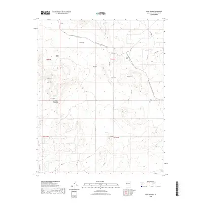
2020 Map of Adams Diggings
USGS Topo · Published 2020About this map
Adams Diggings sits at the heart of this high-altitude landscape in Catron County, a place defined by its relationship with the Continental Divide National Scenic Trail which winds across the northern and eastern reaches. The terrain transition is sharp between the broad expanse of Techado Flat and the prominent elevations of Mariano Mesa and Cat Hill. This 2020 survey documents a network of named draws and canyons, such as Sweazea Draw and Dudley Canyon, which have long served as the primary conduits for seasonal water and travel. The inclusion of Forest Hill Cem near the junction of Graveyard Rd and the main trail highlights the enduring human presence in this high-desert environment. Essential water sources, including Pine Canyon Spring and Techado Spring, remain clearly marked, indicating the sparse but vital hydrology that supports life and movement through this corner of New Mexico.
Find a feature on this map
37 named features on this map. Tap any name to fly to it.
Don’t see what you’re looking for? This feature index may not catch every label — zoom into the map to look around manually.
Map Details
Editions of this 2020 Adams Diggings Map
This is the sole edition of this map. No revisions or reprints were ever made.
Other maps of this area

1954 · Saint Johns
USGS Topo · 1:250,000

1957 · Saint Johns
USGS Topo · 1:250,000

1958 · Saint Johns
USGS Topo · 1:250,000

1962 · Saint Johns
USGS Topo · 1:250,000

1967 · Omega
USGS Topo · 1:24,000

1967 · Mariano Springs
USGS Topo · 1:24,000

1967 · Adams Diggings
USGS Topo · 1:24,000

1967 · Blue Hills
USGS Topo · 1:24,000
1967 · Pie Town
USGS Topo · 1:24,000

1967 · Veteado Mountain
USGS Topo · 1:24,000