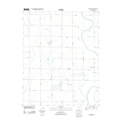
2012 Map of Adamsville
USGS Topo · Published 2012About this map
The Arkansas River meanders across this rural landscape in southeastern Sumner County, defining a region where river-bottom agriculture meets an established energy economy. Small settlements like Adamsville, Paton, and Rainbow Bend anchor the gridded sections of the Kansas plains, while the legacy of early 20th-century petroleum production remains visible through the Lee Oil Field, Holman Oil Field, and the Rainbow Bend Oil Field. These fields suggest a period of industrial activity that once transformed the quiet prairie into a bustling resource hub.
Find a feature on this map
43 named features on this map. Tap any name to fly to it.
Don’t see what you’re looking for? This feature index may not catch every label — zoom into the map to look around manually.
Map Details
Editions of this 2012 Adamsville Map
This is the sole edition of this map. No revisions or reprints were ever made.
Other maps of this area

1890 · Wellington
USGS Topo · 1:125,000

1955 · Wichita
USGS Topo · 1:250,000

1958 · Wichita
USGS Topo · 1:250,000

1964 · South Haven NE
USGS Topo · 1:24,000

1964 · Dalton
USGS Topo · 1:24,000

1965 · Portland
USGS Topo · 1:24,000

1965 · Arkansas City
USGS Topo · 1:24,000

1965 · Adamsville
USGS Topo · 1:24,000

1965 · Geuda Springs
USGS Topo · 1:24,000
1965 · Hackney
USGS Topo · 1:24,000