
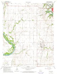
1965 Map of Geuda Springs
USGS Topo · Published 1966About this map
Geuda Springs sits at the northern edge of this landscape where the Sumner Co Cowley Co line meets the Arkansas River. The region in the mid-1960s is defined by a mix of agricultural township lines, such as Walton and Murphy, and an active energy sector visible in the Padgett Oil Field and Bolton Gas and Oil Field. A notable historical artifact is the Old Indian Treaty Boundary cutting across the central section, marking a legacy of frontier surveying that persists alongside mid-century infrastructure like Strother Air Field No 2. Local life is anchored by rural institutions, including Centerview Sch and Mt Hope Ch, while the Atchison Topeka and Santa Fe railroad bisects the prairie through Ashton. The presence of an Old Railroad Grade further suggests the shifting transportation patterns as the area's rail-and-river economy evolved.
Find a feature on this map
26 named features on this map. Tap any name to fly to it.
Don’t see what you’re looking for? This feature index may not catch every label — zoom into the map to look around manually.
Map Details
Editions of this 1965 Geuda Springs Map
This is the sole edition of this map. No revisions or reprints were ever made.
Other maps of this area

1890 · Wellington
USGS Topo · 1:125,000

1955 · Wichita
USGS Topo · 1:250,000

1955 · Enid
USGS Topo · 1:250,000

1958 · Enid
USGS Topo · 1:250,000

1958 · Wichita
USGS Topo · 1:250,000

1964 · South Haven NE
USGS Topo · 1:24,000

1965 · Portland
USGS Topo · 1:24,000

1965 · Arkansas City
USGS Topo · 1:24,000

1965 · Adamsville
USGS Topo · 1:24,000
1965 · Hackney
USGS Topo · 1:24,000