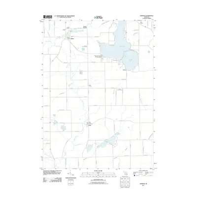
2011 Map of Addison
USGS Topo · Published 2011About this map
Addison and Manitou Beach serve as the primary hubs in this part of Rollin Township, where the landscape is defined by a dense network of glacial lakes and agricultural drains. The village of Addison is situated at the head of Bean Creek, just downstream from the Addison Millpond, while the community of Manitou Beach occupies the western shore of the large Devils Lake. For genealogists, the map is remarkably thorough, locating numerous rural burial sites including the Sherman Farm Cemetery, Quaker Cemetery, and Rollin Center Cemetery. This survey shows a sophisticated drainage system, featuring works like the Garrison Drain and O'Harrow Drain, which supported the region's transition from wetlands to productive farmland. Transport routes like N Kiel Hwy and Meridian Rd connect these lakefront settlements to the smaller hamlets of Geneva and Rollin further south.
Find a feature on this map
94 named features on this map. Tap any name to fly to it.
Don’t see what you’re looking for? This feature index may not catch every label — zoom into the map to look around manually.
Map Details
Editions of this 2011 Addison Map
This is the sole edition of this map. No revisions or reprints were ever made.
Other maps of this area

1935 · Jackson
USGS Topo · 1:48,000

1939 · Jackson
USGS Topo · 1:62,500

1948 · Manchester
USGS Topo · 1:62,500

1949 · Manchester
USGS Topo · 1:62,500

1953 · Fort Wayne
USGS Topo · 1:250,000

1956 · Fort Wayne
USGS Topo · 1:250,000

1958 · Grand Rapids
USGS Topo · 1:250,000

1961 · Grand Rapids
USGS Topo · 1:250,000

1962 · Grand Rapids
USGS Topo · 1:250,000
1962 · Clayton
USGS Topo · 1:24,000