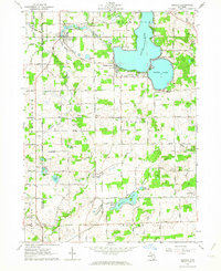
1962 Map of Addison
USGS Topo · Published 1984About this map
The Addison Millpond and the upper reaches of Bean Creek anchor this landscape at the intersection of the Hillsdale and Lenawee county line in the early 1960s. The village of Addison shows a concentrated residential core served by a prominent Water Tank, while the resort-oriented shorelines of Devils Lake and Round Lake are densely lined with structures, including a localized settlement at Manitou Beach. An old railroad grade traces a diagonal path from the northwest toward the village center, marking the evolution of transportation in the region. Rural life is well-documented through scattered gravel pits, local cemeteries such as Greens Cem, and the Rollin Center Ch situated near a Radio Tower. Farther south, the environment transitions toward the smaller basins of Posey Lake and Little Posey Lake, where a Boy Scout Camp is located along the water's edge.
Find a feature on this map
59 named features on this map. Tap any name to fly to it.
Don’t see what you’re looking for? This feature index may not catch every label — zoom into the map to look around manually.
Map Details
Editions of this 1962 Addison Map
This is the sole edition of this map. No revisions or reprints were ever made.
Other maps of this area

1935 · Jackson
USGS Topo · 1:48,000

1939 · Jackson
USGS Topo · 1:62,500

1948 · Manchester
USGS Topo · 1:62,500

1949 · Manchester
USGS Topo · 1:62,500

1953 · Fort Wayne
USGS Topo · 1:250,000

1956 · Fort Wayne
USGS Topo · 1:250,000

1958 · Grand Rapids
USGS Topo · 1:250,000

1961 · Grand Rapids
USGS Topo · 1:250,000

1962 · Grand Rapids
USGS Topo · 1:250,000
1962 · Clayton
USGS Topo · 1:24,000