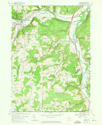
1969 Map of Addison
USGS Topo · Published 1971About this map
The Canisteo River and Tioga River valleys converge in this late 1960s study of Steuben County, New York. The landscape is defined by the intersection of major rail lines, with the Erie-Lackawanna following the northern riverbend near Addison and the Penn Central running south through Lindley toward the Pennsylvania border. Agriculture and local industry are evidenced by the Towner Farm Airfield and a Gravel Pit near Presho, while the southern hills remain largely undeveloped within the State Forest Preserve.
Find a feature on this map
76 named features on this map. Tap any name to fly to it.
Don’t see what you’re looking for? This feature index may not catch every label — zoom into the map to look around manually.
Map Details
Editions of this 1969 Addison Map
3 editions found
Other maps of this area

1900 · Tioga
USGS Topo · 1:62,500

1900 · Elkland
USGS Topo · 1:62,500

1902 · Tioga
USGS Topo · 1:62,500

1914 · Corning
USGS Topo · 1:62,500

1924 · Woodhull
USGS Topo · 1:48,000

1926 · Woodhull
USGS Topo · 1:62,500

1944 · Woodhull
USGS Topo · 1:62,500

1944 · Corning
USGS Topo · 1:62,500

1950 · Elmira
USGS Topo · 1:250,000

1953 · Campbell
USGS Topo · 1:24,000