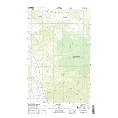
2017 Map of Addy Mountain
USGS Topo · Published 2017About this map
The Little Pend Oreille National Wildlife Refuge and Colville National Forest dominate this 2017 landscape in Stevens County, where the high country of the Iron Mountains and Addy Mountain overlooks the fertile Colville Valley. This mountainous terrain is defined by its drainages, with the Little Pend Oreille River and Colville River serving as primary corridors for both water and road networks. Smaller alpine features like Dailey Lake, Long Lake, and Hatch Lake are reached by a network of forest roads and the historic Old-Timer's Horse Trail. Along the valley floor, routes such as Old Highway 12 Mile Rd and Old Arden Hwy indicate the shifting path of regional transportation over time, while landmarks like Castle Rock and The Butte provide prominent orientation points for those navigating the rugged elevations between Foster Canyon and Addy Basin.
Find a feature on this map
61 named features on this map. Tap any name to fly to it.
Don’t see what you’re looking for? This feature index may not catch every label — zoom into the map to look around manually.
Map Details
Editions of this 2017 Addy Mountain Map
This is the sole edition of this map. No revisions or reprints were ever made.
Other maps of this area

1927 · Chewelah
USGS Topo · 1:125,000

1929 · Colville
USGS Topo · 1:125,000

1930 · Chewelah
USGS Topo · 1:125,000

1933 · Colville
USGS Topo · 1:125,000

1952 · White Mud Lake
USGS Topo · 1:24,000

1952 · Colville
USGS Topo · 1:24,000

1958 · Sandpoint
USGS Topo · 1:250,000

1963 · Sandpoint
USGS Topo · 1:250,000

1964 · Chewelah
USGS Topo · 1:24,000

1964 · Cliff Ridge
USGS Topo · 1:24,000