
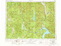
1958 Map of Sandpoint
USGS Topo · Published 1966About this map
Pend Oreille Lake dominates the southeastern quadrant of this Inland Northwest survey, serving as a hub for both industry and wilderness recreation during the mid-century. Infrastructure like the Cabinet Gorge Dam and Albeni Falls Dam illustrates the era's focus on hydroelectric power and water management along the Pend Oreille River. The map details a complex network of transportation, where railroads such as the Great Northern and Spokane International connect small timber and mining settlements like Metaline Falls, Ione, and Cusick. Vast protected lands, including the Colville National Forest and Kaniksu National Forest, surround these hubs, highlighting the region's reliance on natural resources. Genealogists may find interest in the precise locations of remote outposts like the Falls Ranger Station or the small railroad stops of Penrith Station and Thama Station that once supported the local mountain economy.
Find a feature on this map
321 named features on this map. Tap any name to fly to it.
Don’t see what you’re looking for? This feature index may not catch every label — zoom into the map to look around manually.
Map Details
Editions of this 1958 Sandpoint Map
2 editions found
Other maps of this area

1901 · Sandpoint
USGS Topo · 1:125,000

1901 · Spokane
USGS Topo · 1:125,000

1903 · Rathdrum
USGS Topo · 1:125,000

1909 · Cataldo
USGS Topo · 1:125,000

1911 · Cataldo
USGS Topo · 1:125,000

1911 · Priest Lake
USGS Topo · 1:250,000

1911 · Sandpoint
USGS Topo · 1:125,000

1913 · Priest Lake
USGS Topo · 1:250,000

1920 · Libby
USGS Topo · 1:125,000

1927 · Chewelah
USGS Topo · 1:125,000