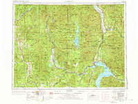
1958 Map of Sandpoint
USGS Topo · Published 1975About this map
Sandpoint serves as a vital hub where the Northern Pacific RR and Great Northern RR converge near the northern reaches of Lake Pend Oreille. This mid-century survey illustrates a landscape defined by timber and hydroelectric potential, centered on the Pend Oreille River and its tributaries. The construction of the Albeni Falls Dam near Oldtown and Newport significantly altered the river's flow, supporting regional industrial growth evidenced by a Factory and Sawmill appearing along the waterways.
Find a feature on this map
270 named features on this map. Tap any name to fly to it.
Don’t see what you’re looking for? This feature index may not catch every label — zoom into the map to look around manually.
Map Details
Editions of this 1958 Sandpoint Map
2 editions found

Other maps of this area

1901 · Sandpoint
USGS Topo · 1:125,000

1901 · Spokane
USGS Topo · 1:125,000

1903 · Rathdrum
USGS Topo · 1:125,000

1909 · Cataldo
USGS Topo · 1:125,000

1911 · Cataldo
USGS Topo · 1:125,000

1911 · Priest Lake
USGS Topo · 1:250,000

1911 · Sandpoint
USGS Topo · 1:125,000

1913 · Priest Lake
USGS Topo · 1:250,000

1920 · Libby
USGS Topo · 1:125,000

1927 · Chewelah
USGS Topo · 1:125,000