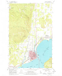
1968 Map of Sandpoint
USGS Topo · Published 1978About this map
Lake Pend Oreille dominates the eastern landscape where it meets the Pend Oreille River at the growing hub of Sandpoint. This late-1960s survey illustrates a community deeply tied to its geography and transportation infrastructure, with the Great Northern and Spokane Northern railroads converging near the waterfront. In the city center, a dense grid of streets like Cedar St and Pine St surrounds civic landmarks including the Courthouse, Library, and City Hall.
Find a feature on this map
63 named features on this map. Tap any name to fly to it.
Don’t see what you’re looking for? This feature index may not catch every label — zoom into the map to look around manually.
Map Details
Editions of this 1968 Sandpoint Map
2 editions found
Other maps of this area

1901 · Sandpoint
USGS Topo · 1:125,000

1911 · Priest Lake
USGS Topo · 1:250,000

1911 · Sandpoint
USGS Topo · 1:125,000

1913 · Priest Lake
USGS Topo · 1:250,000

1949 · Packsaddle Mtn
USGS Topo · 1:62,500

1951 · Packsaddle Mtn
USGS Topo · 1:62,500

1951 · Elmira
USGS Topo · 1:62,500

1958 · Sandpoint
USGS Topo · 1:250,000

1963 · Sandpoint
USGS Topo · 1:250,000
1968 · Happy Fork Gap
USGS Topo · 1:24,000