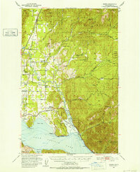
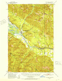
1951 Map of Elmira
USGS Topo · Published 1953About this map
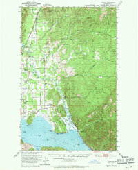
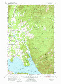
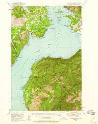
Pend Oreille Lake dominates the southern landscape of this 1950s survey, showing the shoreline just as the Albeni Falls Dam project was poised to submerge sections of the coast, marked here by blue hatching. The area's educational history is frozen in time, with several rural schoolhouses already noted as abandoned, including the Grouse Creek (Aban'd) Sch and Center Valley Sch (Aban'd). The transportation network is defined by the Great Northern and Spokane International railroads, which parallel the highway through settlements like Elmira and Samuels. Further east, the rugged peaks of the Kaniksu National Forest rise sharply, including Elmira Peak and Wylie Knob. This map records a transition in the Pack River valley, where the rural economy was shifting from timber and small-scale rail sidings like Forest Siding toward the modern landscape shaped by hydroelectric development and forest management.
Find a feature on this map
60 named features on this map. Tap any name to fly to it.
Don’t see what you’re looking for? This feature index may not catch every label — zoom into the map to look around manually.
Map Details
Editions of this 1951 Elmira Map
3 editions found
Other maps of this area

1901 · Sandpoint
USGS Topo · 1:125,000

1911 · Priest Lake
USGS Topo · 1:250,000

1911 · Sandpoint
USGS Topo · 1:125,000

1913 · Priest Lake
USGS Topo · 1:250,000
1949 · Packsaddle Mtn
USGS Topo · 1:62,500

1951 · Packsaddle Mtn
USGS Topo · 1:62,500
1951 · Clark Fork
USGS Topo · 1:62,500
1951 · Mt Pend Oreille
USGS Topo · 1:62,500

1958 · Sandpoint
USGS Topo · 1:250,000

1963 · Sandpoint
USGS Topo · 1:250,000