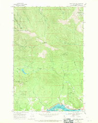
1968 Map of Happy Fork Gap
USGS Topo · Published 1971About this map
The Pend Oreille River corridor defines the southern edge of this Idaho territory, serving as a primary transportation artery in the late 1960s. Parallel tracks of the Great Northern and Spokane International railroads trace the riverbank, passing through the small community of Wrencoe and near Little Muskrat Lake. To the north, the landscape shifts abruptly into the high-elevation terrain of the Kaniksu National Forest.
Find a feature on this map
38 named features on this map. Tap any name to fly to it.
Don’t see what you’re looking for? This feature index may not catch every label — zoom into the map to look around manually.
Map Details
Editions of this 1968 Happy Fork Gap Map
2 editions found
Other maps of this area

1901 · Sandpoint
USGS Topo · 1:125,000

1911 · Priest Lake
USGS Topo · 1:250,000

1911 · Sandpoint
USGS Topo · 1:125,000

1913 · Priest Lake
USGS Topo · 1:250,000

1958 · Sandpoint
USGS Topo · 1:250,000

1963 · Sandpoint
USGS Topo · 1:250,000

1967 · Coolin
USGS Topo · 1:24,000

1967 · Prater Mtn
USGS Topo · 1:24,000
1968 · Morton
USGS Topo · 1:24,000
1968 · Mount Casey
USGS Topo · 1:24,000