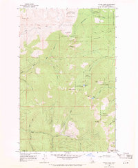
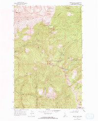
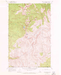
1968 Map of Mount Casey
USGS Topo · Published 1971About this map
Kaniksu National Forest dominates this Idaho landscape, where high-elevation landmarks and timber-access routes define the topography of the late 1960s. The area is characterized by a network of named peaks and ridges, including the prominent Sundance Mtn and Hellroaring Ridge, which overlook a complex drainage system fed by Hellroaring Creek and Chicopee Creek. Human activity is concentrated around surveying and resource extraction, evidenced by the presence of the Caribou Lookout and a Prospect located near Keokee Mtn. A significant portion of the terrain is accessible only by Jeep Trail or foot path, highlighting the remote nature of the Schweitzer Basin and the high basins holding Caribou Lake and Colburn Lake. These trails suggest a history of forestry management and seasonal outdoor activity long before more modern developments reached these reaches of Bonner County.
Find a feature on this map
28 named features on this map. Tap any name to fly to it.
Don’t see what you’re looking for? This feature index may not catch every label — zoom into the map to look around manually.
Map Details
Editions of this 1968 Mount Casey Map
2 editions found
Other maps of this area

1901 · Sandpoint
USGS Topo · 1:125,000

1911 · Priest Lake
USGS Topo · 1:250,000

1911 · Sandpoint
USGS Topo · 1:125,000

1913 · Priest Lake
USGS Topo · 1:250,000

1958 · Sandpoint
USGS Topo · 1:250,000

1963 · Sandpoint
USGS Topo · 1:250,000
1967 · Priest Lake SE
USGS Topo · 1:24,000
1967 · Coolin
USGS Topo · 1:24,000
1967 · Mount Roothaan
USGS Topo · 1:24,000
1967 · Prater Mtn
USGS Topo · 1:24,000