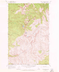
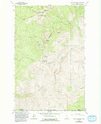
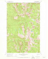
1967 Map of Mount Roothaan
USGS Topo · Published 1971About this map
Horton Lookout Tower stands as a primary sentinel overlooking the high-altitude landscape of the Kaniksu National Forest in this 1960s survey. The terrain is characterized by sharp vertical relief, with notable summits like Mount Roothaan, Gunsight Peak, and the distinctive Chimney Rock dominating the Selkirk Mountains skyline. Water features are abundant but confined to steep drainages and glacial cirques, including Hunt Lake, Fault Lake, and McCormick Lake. The map details the transition across the Boundary and Bonner County line, tracing the headwaters of the West Branch Priest River and South Fork Indian Creek. This remote backcountry was largely accessed via specialized routes such as a Jeep Trail and the high-elevation Horton Ridge, reflecting a period of forest management and fire lookout operations before significant modern developments in the Idaho Panhandle wilderness.
Find a feature on this map
25 named features on this map. Tap any name to fly to it.
Don’t see what you’re looking for? This feature index may not catch every label — zoom into the map to look around manually.
Map Details
Editions of this 1967 Mount Roothaan Map
2 editions found
Other maps of this area

1901 · Sandpoint
USGS Topo · 1:125,000

1911 · Priest Lake
USGS Topo · 1:250,000

1911 · Sandpoint
USGS Topo · 1:125,000

1913 · Priest Lake
USGS Topo · 1:250,000

1958 · Sandpoint
USGS Topo · 1:250,000

1963 · Sandpoint
USGS Topo · 1:250,000
1967 · Priest Lake SE
USGS Topo · 1:24,000
1967 · Coolin
USGS Topo · 1:24,000
1967 · Priest Lake NE
USGS Topo · 1:24,000
1967 · The Wigwams
USGS Topo · 1:24,000