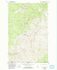
1967 Map of Mount Roothaan
USGS Topo · Published 1993About this map
Horton Ridge and its Lookout Tower anchor the high country of this mid-century survey, which details a landscape dominated by the sharp granite formations and high basins of the Kaniksu National Forest. The topography is defined by the Selkirk Mountains' dramatic crests, including Mount Roothaan and the iconic needle of Chimney Rock. High-altitude water bodies such as Hunt Lake, Fault Lake, and McCormick Lake are tucked into the cirques below Gunsight Peak and Hunt Peak, illustrating the glacial carving of the region.
Find a feature on this map
31 named features on this map. Tap any name to fly to it.
Don’t see what you’re looking for? This feature index may not catch every label — zoom into the map to look around manually.
Map Details
Editions of this 1967 Mount Roothaan Map
2 editions found

Other maps of this area

1901 · Sandpoint
USGS Topo · 1:125,000

1911 · Priest Lake
USGS Topo · 1:250,000

1911 · Sandpoint
USGS Topo · 1:125,000

1913 · Priest Lake
USGS Topo · 1:250,000

1958 · Sandpoint
USGS Topo · 1:250,000

1963 · Sandpoint
USGS Topo · 1:250,000

1967 · Priest Lake SE
USGS Topo · 1:24,000

1967 · Coolin
USGS Topo · 1:24,000

1967 · Priest Lake NE
USGS Topo · 1:24,000

1967 · The Wigwams
USGS Topo · 1:24,000