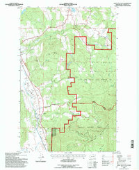
1992 Map of Addy Mountain
USGS Topo · Published 1997About this map
The Colville Valley floor serves as a primary corridor for transportation and settlement in the early 1990s, anchored by the community of Arden and the Burlington Northern railroad line. The western portion of the map follows the winding course of the Colville River, which is fed by numerous tributaries including Stranger Creek and Twelvemile Creek. A notable landmark for local historians is the Twelvemile Sch, situated near the valley bottom before the terrain rises sharply into the surrounding highlands.
Find a feature on this map
28 named features on this map. Tap any name to fly to it.
Don’t see what you’re looking for? This feature index may not catch every label — zoom into the map to look around manually.
Map Details
Editions of this 1992 Addy Mountain Map
This is the sole edition of this map. No revisions or reprints were ever made.
Other maps of this area

1927 · Chewelah
USGS Topo · 1:125,000

1929 · Colville
USGS Topo · 1:125,000

1930 · Chewelah
USGS Topo · 1:125,000

1933 · Colville
USGS Topo · 1:125,000

1952 · White Mud Lake
USGS Topo · 1:24,000

1952 · Colville
USGS Topo · 1:24,000

1958 · Sandpoint
USGS Topo · 1:250,000

1963 · Sandpoint
USGS Topo · 1:250,000

1964 · Chewelah
USGS Topo · 1:24,000

1964 · Cliff Ridge
USGS Topo · 1:24,000