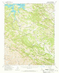
1961 Map of Adelaida
USGS Topo · Published 1968About this map
Nacimiento Reservoir and the Nacimiento River dominate the northern terrain of this Central Coast landscape, which transitions from the northern reach of the Santa Lucia Range toward the agricultural valleys to the east. The map captures a rural economy defined by a mix of ranching and mining, with operations like the Klau Mine, Buena Vista Mine, and Oceanic Mine scattered through the hills. This 1961 field-checked survey documents a network of family-held lands such as Kentucky Ranch and the uniquely named Vitamin D Ranch.
Find a feature on this map
70 named features on this map. Tap any name to fly to it.
Don’t see what you’re looking for? This feature index may not catch every label — zoom into the map to look around manually.
Map Details
Editions of this 1961 Adelaida Map
This is the sole edition of this map. No revisions or reprints were ever made.
Other maps of this area

1897 · San Luis Obispo
USGS Topo · 1:62,500

1897 · Cayucos
USGS Topo · 1:62,500

1900 · San Luis
USGS Topo · 1:125,000

1919 · San Miguel
USGS Topo · 1:62,500

1919 · Bryson
USGS Topo · 1:62,500

1919 · Paso Robles
USGS Topo · 1:62,500

1919 · Bradley
USGS Topo · 1:62,500

1919 · Adelaida
USGS Topo · 1:62,500

1919 · San Simeon
USGS Topo · 1:62,500

1932 · Adelaida
USGS Topo · 1:62,500