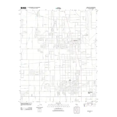
2012 Map of Adelanto
USGS Topo · Published 2012About this map
Adelanto and its surrounding High Desert landscapes are captured in this 2012 survey, showing a period of significant municipal expansion and specialized aviation infrastructure. The map details the transition from the residential core of the city to the expansive Southern California Logistics Airport in the east, highlighting the region's role as a major logistics hub. To the south, the developments of South Adelanto and the crossroads at Adobe Corners illustrate the steady growth of the desert community. The natural terrain is defined by the broad path of Fremont Wash, which cuts across the western portion of the quadrangle. Smaller residential enclaves like Mountain View and the private Adelanto Airport are situated among a vast grid of streets such as El Mirage Rd and Bartlett Ave, reflecting the suburban desert planning typical of San Bernardino County.
Find a feature on this map
148 named features on this map. Tap any name to fly to it.
Don’t see what you’re looking for? This feature index may not catch every label — zoom into the map to look around manually.
Map Details
Editions of this 2012 Adelanto Map
This is the sole edition of this map. No revisions or reprints were ever made.
Other maps of this area

1901 · Southern California Sheet No. 1
USGS Topo · 1:250,000

1902 · Hesperia
USGS Topo · 1:62,500

1903 · San Antonio
USGS Topo · 1:62,500

1904 · Southern California Sheet No. 1
USGS Topo · 1:250,000

1932 · Barstow
USGS Topo · 1:125,000

1934 · Barstow
USGS Topo · 1:125,000

1937 · Shadow Mountains
USGS Topo · 1:48,000
1942 · San Antonio
USGS Topo · 1:62,500

1942 · Hesperia
USGS Topo · 1:62,500

1942 · Shadow Mountains
USGS Topo · 1:62,500