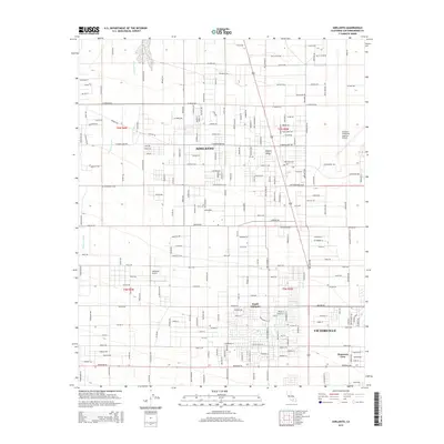
2015 Map of Adelanto
USGS Topo · Published 2015About this map
Adelanto and its neighboring communities are situated within the expansive high-desert terrain of the Mojave Desert in San Bernardino County. This 2015 survey illustrates a landscape defined by significant infrastructure and transportation-led development, with the Adelanto Airport and major thoroughfares like Air Expressway Blvd and El Mirage Rd shaping the local economy. The mapping of South Adelanto and parts of Victorville, including the neighborhood of Mountain View, shows a distinct grid-pattern expansion into the arid landscape. Natural features are dominated by the broad course of Fremont Wash, which cuts through the northwestern portion of the map, serving as a reminder of the hydrological forces that shape this desert region even as urban development continues its eastward push toward the Southern California Logistics Airport boundary.
Find a feature on this map
154 named features on this map. Tap any name to fly to it.
Don’t see what you’re looking for? This feature index may not catch every label — zoom into the map to look around manually.
Map Details
Editions of this 2015 Adelanto Map
This is the sole edition of this map. No revisions or reprints were ever made.
Other maps of this area

1901 · Southern California Sheet No. 1
USGS Topo · 1:250,000

1902 · Hesperia
USGS Topo · 1:62,500

1903 · San Antonio
USGS Topo · 1:62,500

1904 · Southern California Sheet No. 1
USGS Topo · 1:250,000

1932 · Barstow
USGS Topo · 1:125,000

1934 · Barstow
USGS Topo · 1:125,000

1937 · Shadow Mountains
USGS Topo · 1:48,000
1942 · San Antonio
USGS Topo · 1:62,500

1942 · Hesperia
USGS Topo · 1:62,500

1942 · Shadow Mountains
USGS Topo · 1:62,500