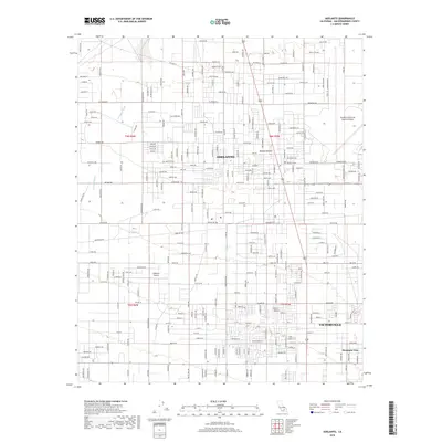
2018 Map of Adelanto
USGS Topo · Published 2018About this map
The High Desert community of Adelanto occupies the heart of this 2018 survey, appearing alongside the northwestern expansion of Victorville and the neighborhood of Mountain View. The landscape is defined by the stark transition from residential and industrial development to the open reaches of the Mojave Desert, particularly evident as the grid of streets dissolves into the dry drainage of Fremont Wash. Aviation history and utility are central to the area's layout, dominated by the sprawling infrastructure of the Southern California Logistics Airport on the eastern edge and the smaller Adelanto Airport further west. Notable thoroughfares such as El Mirage Rd and Perimeter Rd frame the northern reaches of the city, while numerous named residential streets like Calleja Rd and Bella Vista Rd trace the modern growth patterns of these San Bernardino County desert hubs.
Find a feature on this map
94 named features on this map. Tap any name to fly to it.
Don’t see what you’re looking for? This feature index may not catch every label — zoom into the map to look around manually.
Map Details
Editions of this 2018 Adelanto Map
This is the sole edition of this map. No revisions or reprints were ever made.
Other maps of this area

1901 · Southern California Sheet No. 1
USGS Topo · 1:250,000

1902 · Hesperia
USGS Topo · 1:62,500

1903 · San Antonio
USGS Topo · 1:62,500

1904 · Southern California Sheet No. 1
USGS Topo · 1:250,000

1932 · Barstow
USGS Topo · 1:125,000

1934 · Barstow
USGS Topo · 1:125,000

1937 · Shadow Mountains
USGS Topo · 1:48,000
1942 · San Antonio
USGS Topo · 1:62,500

1942 · Hesperia
USGS Topo · 1:62,500

1942 · Shadow Mountains
USGS Topo · 1:62,500