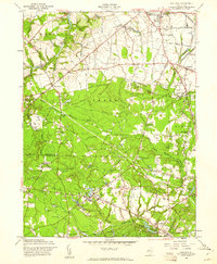
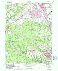
1957 Map of Adelphia
USGS Topo · Published 1961About this map
The agricultural and industrial character of central New Jersey is evident in this mid-century survey, defined by a network of mills and specialized farming sites. Millhurst, Oakland Mills, Wyckoff Mills, Jacksons Mills, and Bennetts Mills are scattered across the landscape, marking the historical importance of local waterpower along the Manalapan Brook and the North Branch Metedeconk River. The extensive presence of Cranberry Bogs throughout the southern half of the map, particularly around Siloam and Harmony, highlights the region's specific agricultural legacy in the acidic soils of the Pine Barrens fringe. Connectivity is provided by the Pennsylvania railroad line cutting through the northeast corner near Adelphia, while local landmarks like the Township Sch in West Freehold and the community at Charleston Springs anchor the rural neighborhoods of Manalapan and Freehold townships.
Find a feature on this map
39 named features on this map. Tap any name to fly to it.
Don’t see what you’re looking for? This feature index may not catch every label — zoom into the map to look around manually.
Map Details
Editions of this 1957 Adelphia Map
5 editions found
Other maps of this area

1888 · New Brunswick
USGS Topo · 1:62,500

1888 · Asbury Park
USGS Topo · 1:62,500

1888 · Cassville
USGS Topo · 1:62,500

1888 · Sandy Hook
USGS Topo · 1:62,500

1893 · New Brunswick
USGS Topo · 1:62,500

1893 · Sandy Hook
USGS Topo · 1:62,500

1893 · Asbury Park
USGS Topo · 1:62,500

1894 · Cassville
USGS Topo · 1:62,500

1900 · Cassville
USGS Topo · 1:62,500

1901 · New Brunswick
USGS Topo · 1:62,500