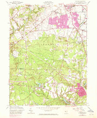
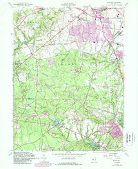
1957 Map of Adelphia
USGS Topo · Published 1971About this map
Jacksons Mills and Bennetts Mills anchor a landscape defined by its milling history and intricate hydrology at the junction of Monmouth and Ocean Counties. The Metedeconk River system, including its North Branch and South Branch, dominates the southern half of the sheet, where extensive Cranberry Bogs signal a long-standing agricultural economy built on the region's wetlands. The northern section reflects a shift toward transportation and early suburbanization, with the Penn Central rail line passing through Jones Siding and expanding urban footprints noted in the 1970 revision purple tint.
Find a feature on this map
41 named features on this map. Tap any name to fly to it.
Don’t see what you’re looking for? This feature index may not catch every label — zoom into the map to look around manually.
Map Details
Editions of this 1957 Adelphia Map
5 editions found
Other maps of this area

1888 · New Brunswick
USGS Topo · 1:62,500

1888 · Asbury Park
USGS Topo · 1:62,500

1888 · Cassville
USGS Topo · 1:62,500

1888 · Sandy Hook
USGS Topo · 1:62,500

1893 · New Brunswick
USGS Topo · 1:62,500

1893 · Sandy Hook
USGS Topo · 1:62,500

1893 · Asbury Park
USGS Topo · 1:62,500

1894 · Cassville
USGS Topo · 1:62,500

1900 · Cassville
USGS Topo · 1:62,500

1901 · New Brunswick
USGS Topo · 1:62,500