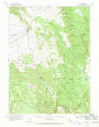
1962 Map of Adin
USGS Topo · Published 1971About this map
Adin serves as the primary settlement on the boundary of Big Valley and Ash Valley, where ranching and forest management define the local landscape. This early 1960s survey details the transition from the high-desert valleys to the timbered heights of the Modoc National Forest. The map documents numerous isolated homesteads and family-named landmarks, such as Dibble Place, Dan Ryan Place, and Knudsen Ranch, which speak to the area's agricultural heritage. These sites are linked by a network of unimproved roads like Bassett Road and Armstrong Road, weaving between volcanic landforms like Brisco Butte. Water management for livestock is evident through features like Myers Reservoir and Cary Reservoir, while the southern reaches include the Modoc State Game Refuge, highlighting the region's importance for wildlife and public land use.
Find a feature on this map
91 named features on this map. Tap any name to fly to it.
Don’t see what you’re looking for? This feature index may not catch every label — zoom into the map to look around manually.
Map Details
Editions of this 1962 Adin Map
2 editions found
Other maps of this area

1886 · Alturas
USGS Topo · 1:250,000

1886 · Honey Lake
USGS Topo · 1:250,000

1886 · Lassen Peak
USGS Topo · 1:250,000

1886 · Modoc Lava Bed
USGS Topo · 1:250,000

1891 · Honey Lake
USGS Topo · 1:250,000

1892 · Modoc Lava-Bed
USGS Topo · 1:250,000

1892 · Lassen Peak
USGS Topo · 1:250,000

1892 · Alturas
USGS Topo · 1:250,000

1893 · Honey Lake
USGS Topo · 1:250,000

1894 · Lassen Peak
USGS Topo · 1:250,000