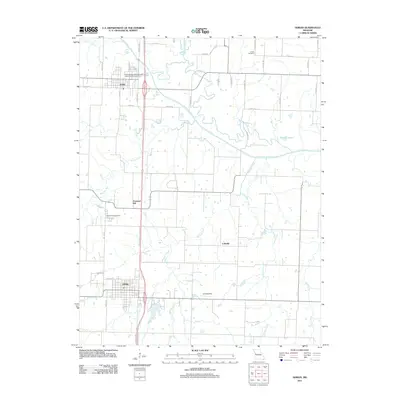
2011 Map of Adrian
USGS Topo · Published 2011About this map
Adrian and Archie anchor the landscape of northern Bates County in this 2011 survey, a region defined by the meandering courses of the South Grand River and its many tributaries. The area maintains a traditional rural layout, with the settlements of Crescent Hill and Coleville serving as local landmarks among the agricultural grid. Genealogists will find the Crescent Hill Cemetery and Austin Cemetery clearly marked, alongside family-named roads like S Dickey Rd and S Cantrell Rd. The drainage network is particularly detailed, showing the intricate paths of Big Deer Creek, Little Deer Creek, and the Mormon Fork. Transportation is dominated by the corridor of Old U.S. Hwy 71, while smaller features like a local Landing Strip and the Archie Wastewater Treatment Lagoon provide specific points of interest for modern land-use research.
Find a feature on this map
44 named features on this map. Tap any name to fly to it.
Don’t see what you’re looking for? This feature index may not catch every label — zoom into the map to look around manually.
Map Details
Editions of this 2011 Adrian Map
This is the sole edition of this map. No revisions or reprints were ever made.
Other maps of this area

1887 · Harrisonville
USGS Topo · 1:125,000

1887 · Butler
USGS Topo · 1:125,000

1892 · Harrisonville
USGS Topo · 1:125,000

1894 · Harrisonville
USGS Topo · 1:125,000

1894 · Butler
USGS Topo · 1:125,000

1947 · Lawrence
USGS Topo · 1:250,000

1950 · Lawrence
USGS Topo · 1:250,000
1953 · Everett
USGS Topo · 1:24,000
1954 · Garden City
USGS Topo · 1:24,000
1954 · Austin
USGS Topo · 1:24,000