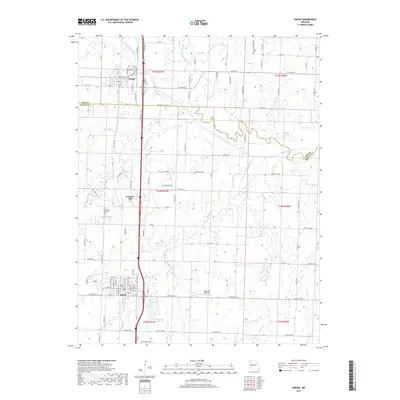
2017 Map of Adrian
USGS Topo · Published 2017About this map
Adrian and Archie anchor this portion of the Missouri landscape, where the modern corridor of S Old US Hwy 71 cuts north-south through the western plains. This area is defined by its extensive drainage network, centered on the winding path of the South Grand River and its numerous tributaries like Mormon Fork, Eightmile Creek, and Big Deer Creek. The map shows a transition from the established street grids of the local towns to the sprawling agricultural tracts of the surrounding countryside, punctuated by small reservoirs and aviation landmarks.
Find a feature on this map
74 named features on this map. Tap any name to fly to it.
Don’t see what you’re looking for? This feature index may not catch every label — zoom into the map to look around manually.
Map Details
Editions of this 2017 Adrian Map
This is the sole edition of this map. No revisions or reprints were ever made.
Other maps of this area

1887 · Harrisonville
USGS Topo · 1:125,000

1887 · Butler
USGS Topo · 1:125,000

1892 · Harrisonville
USGS Topo · 1:125,000

1894 · Harrisonville
USGS Topo · 1:125,000

1894 · Butler
USGS Topo · 1:125,000

1947 · Lawrence
USGS Topo · 1:250,000

1950 · Lawrence
USGS Topo · 1:250,000
1953 · Everett
USGS Topo · 1:24,000
1954 · Garden City
USGS Topo · 1:24,000
1954 · Austin
USGS Topo · 1:24,000