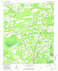
1943 Map of Adrian
USGS Topo · Published 1981About this map
Chinners Swamp and the sprawling Brown Swamp dominate this rural coastal plain landscape, where mid-century drainage patterns and agricultural clearings define the settlement footprint. The local economy and social life are anchored by numerous crossroads communities and rural schools, such as Poplar Hill Sch and Valley Forge Sch. Transportation is centered on the Seaboard Coast Line railroad, which cuts a sharp diagonal across the terrain, passing through Adrian and Homewood. Small family and community landmarks like the Thompson Cem and Mt Aerial Ch provide valuable points of reference for genealogical research. The map reflects a landscape in transition, where legacy swamp names like Bug Swamp and Maple Swamp persist alongside the emerging road networks connecting Baxter Forks and Poplar Forks.
Find a feature on this map
50 named features on this map. Tap any name to fly to it.
Don’t see what you’re looking for? This feature index may not catch every label — zoom into the map to look around manually.
Map Details
Editions of this 1943 Adrian Map
2 editions found
Other maps of this area

1937 · Nixonville
USGS Topo · 1:48,000

1942 · Nixonville
USGS Topo · 1:62,500

1943 · Dongola
USGS Topo · 1:24,000

1943 · Adrian
USGS Topo · 1:24,000

1943 · Horry
USGS Topo · 1:24,000

1943 · Conway
USGS Topo · 1:24,000

1944 · Adrian
USGS Topo · 1:31,680

1948 · Galivants Ferry
USGS Topo · 1:24,000

1948 · Bayboro
USGS Topo · 1:24,000

1949 · Bayboro
USGS Topo · 1:24,000