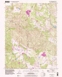
1998 Map of Aetna Springs
USGS Topo · Published 2002About this map
Aetna Springs serves as the focal point for this survey of the northern interior of Napa County, where historical mining and resort recreation define the landscape. Near the settlement, the Aetna Mine and White Rock Mine indicate the region's mineral history, while a nearby Golf Course and Duvall Lake suggest the area's development into a destination for leisure. The complex topography is carved by Butts Canyon and Locoallomi Valley, with the eastern edge of the sheet touching upon the critical spillway elevation of Lake Berryessa.
Find a feature on this map
38 named features on this map. Tap any name to fly to it.
Don’t see what you’re looking for? This feature index may not catch every label — zoom into the map to look around manually.
Map Details
Editions of this 1998 Aetna Springs Map
This is the sole edition of this map. No revisions or reprints were ever made.
Other maps of this area

1927 · Calistoga
USGS Topo · 1:62,500

1942 · St. Helena
USGS Topo · 1:62,500

1943 · Morgan Valley
USGS Topo · 1:62,500

1943 · Calistoga
USGS Topo · 1:62,500

1944 · Morgan Valley
USGS Topo · 1:62,500

1945 · Calistoga
USGS Topo · 1:62,500

1945 · St. Helena
USGS Topo · 1:62,500

1945 · Lower Lake
USGS Topo · 1:62,500

1947 · Santa Rosa
USGS Topo · 1:250,000

1949 · Santa Rosa
USGS Topo · 1:250,000