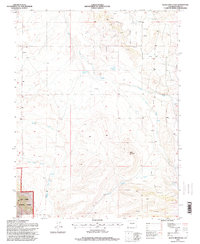
1994 Map of Agate Mountain
USGS Topo · Published 1998About this map
San Isabel National Forest encompasses the southern reaches of this landscape, where the high-altitude terrain is defined by complex drainage systems and extractive industry. In the mid-1990s, the area around Agate Mountain was characterized by numerous Prospects and Quarries, indicating a history of mineral exploration throughout the hills. The settlement of Trump sits in the northwest, serving as a rare point of named habitation in a region primarily used for timber, grazing, and mining.
Find a feature on this map
22 named features on this map. Tap any name to fly to it.
Don’t see what you’re looking for? This feature index may not catch every label — zoom into the map to look around manually.
Map Details
Editions of this 1994 Agate Mountain Map
This is the sole edition of this map. No revisions or reprints were ever made.
Other maps of this area

1954 · Pueblo
USGS Topo · 1:250,000

1956 · Antero Reservoir
USGS Topo · 1:24,000

1956 · Antero Reservoir NE
USGS Topo · 1:24,000

1956 · Guffey NW
USGS Topo · 1:24,000

1956 · Cameron Mountain
USGS Topo · 1:62,500

1957 · Pueblo
USGS Topo · 1:250,000

1958 · Pueblo
USGS Topo · 1:250,000

1959 · Antero Reservoir
USGS Topo · 1:62,500

1959 · Black Mountain
USGS Topo · 1:62,500

1959 · Guffey
USGS Topo · 1:62,500