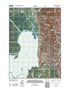
2011 Map of Agency Lake
USGS Topo · Published 2011About this map
Klamath Agency sits at the northern edge of this landscape, marking a site of significant administrative and cultural history near the headwaters of Crooked Creek. The terrain is defined by the expansive waters of Agency Lake and the northern tip of Upper Klamath Lake, separated from the fertile Wood River Valley by a prominent Levee. The map details the intricate hydrography of the region, including the winding Williamson River and the artificial waterways of the Sevenmile Canal and B Canal, which reflect the area's agricultural development.
Find a feature on this map
45 named features on this map. Tap any name to fly to it.
Don’t see what you’re looking for? This feature index may not catch every label — zoom into the map to look around manually.
Map Details
Editions of this 2011 Agency Lake Map
This is the sole edition of this map. No revisions or reprints were ever made.
Other maps of this area

1889 · Klamath
USGS Topo · 1:250,000

1891 · Ashland
USGS Topo · 1:250,000

1893 · Ashland
USGS Topo · 1:250,000

1894 · Klamath
USGS Topo · 1:250,000

1897 · Ashland
USGS Topo · 1:250,000

1955 · Lake O' Woods
USGS Topo · 1:62,500

1955 · Pelican Butte
USGS Topo · 1:62,500

1955 · Klamath Falls
USGS Topo · 1:250,000

1955 · Medford
USGS Topo · 1:250,000

1957 · Medford
USGS Topo · 1:250,000