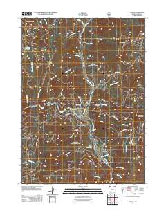
2011 Map of Agness
USGS Topo · Published 2011About this map
The confluence of the Rogue River and Illinois River anchors this coastal range landscape, marking the small settlement of Agness. This river-driven geography is characterized by numerous river bars and eddies, including Walker Bar, Lynch Bar, and the distinctively named Tom Fry Eddy near Agness Bar. The presence of the Agness Post Office and Oak Flats Cemetery highlights the community's established local history in a region defined by steep drainages and prominent summits like Sevenmile Peak and Raspberry Mountain. Small-scale infrastructure is visible through the Bolan Lake Dam and a network of forest development roads such as Nat For Dev Rd 3336, which navigate the deep cuts of Copper Canyon and Shasta Costa Creek. This survey captures the isolated character of the Rogue River canyon before the modern era of expanded access.
Find a feature on this map
52 named features on this map. Tap any name to fly to it.
Don’t see what you’re looking for? This feature index may not catch every label — zoom into the map to look around manually.
Map Details
Editions of this 2011 Agness Map
This is the sole edition of this map. No revisions or reprints were ever made.
Other maps of this area

1899 · Port Orford
USGS Topo · 1:125,000

1903 · Port Orford
USGS Topo · 1:125,000

1917 · Kerby
USGS Topo · 1:125,000

1918 · Kerby
USGS Topo · 1:125,000

1945 · Kerby
USGS Topo · 1:125,000

1954 · Coos Bay
USGS Topo · 1:250,000

1954 · Marial
USGS Topo · 1:62,500

1954 · Collier Butte
USGS Topo · 1:62,500

1954 · Agness
USGS Topo · 1:62,500

1954 · Pearsoll Peak
USGS Topo · 1:62,500