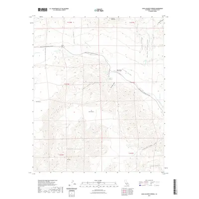
2021 Map of Agua Caliente Springs
USGS Topo · Published 2021About this map
The Great Southern Overland Stage Rte traces a historic transportation corridor through this arid landscape, passing the Vallecito Stage Station Cem where it meets Vallecito Creek. The map documents a rugged desert environment defined by the Tierra Blanca Mountains and the Sawtooth Mountains, where water remains the primary driver of geography. Notable water sources such as Agua Caliente Springs and Burro Spring anchor the few points of human interest, including the Agua Caliente Springs Airport. The terrain is deeply incised by drainages like Canebrake Canyon, Ironwood Canyon, and Smuggler Canyon, illustrating the complex drainage patterns of the Carrizo Valley and Vallecito Valley. This contemporary survey preserves the names of distinct landmarks like Red Top and The Potrero, which have served as navigational waypoints for travelers in this part of San Diego County for generations.
Find a feature on this map
37 named features on this map. Tap any name to fly to it.
Don’t see what you’re looking for? This feature index may not catch every label — zoom into the map to look around manually.
Map Details
Editions of this 2021 Agua Caliente Springs Map
This is the sole edition of this map. No revisions or reprints were ever made.
Other maps of this area

1931 · Vallecito
USGS Topo · 1:125,000

1931 · Carrizo
USGS Topo · 1:125,000

1939 · Borrego
USGS Topo · 1:62,500

1942 · Barrel Spring
USGS Topo · 1:62,500

1942 · Borego
USGS Topo · 1:62,500

1942 · Carrizo Mtn
USGS Topo · 1:62,500

1942 · Cuyapaipe
USGS Topo · 1:62,500

1943 · Vallecito
USGS Topo · 1:125,000

1947 · Santa Ana
USGS Topo · 1:250,000
1947 · Barrel Spring
USGS Topo · 1:62,500