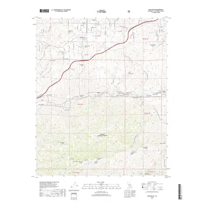
2018 Map of Agua Dulce
USGS Topo · Published 2018About this map
Sierra Pelona Valley and the northern slopes of the San Gabriel Mountains dominate this landscape within the Angeles National Forest. The geography is defined by a series of southwest-running drainages such as Agua Dulce Canyon, Escondido Canyon, and Bee Canyon, which feed toward the Santa Clara River near the small settlements of Russ and Lang. The presence of the Pacific Crest National Scenic Trail winding through the high ground above Three Sisters Rock and Vasquez Rocks highlights the region's significance for modern recreation and conservation. Transportation is funneled through the natural corridors of the canyons, with Soledad Canyon Rd and the Agua Dulce Airport serving as primary transit points between the high peaks of Magic Mtn and the northern valleys. Local landmarks like Saddleback Mtn and Quail Spring provide specific points of reference for those studying the complex topography and historical land use of this Los Angeles County interior.
Find a feature on this map
54 named features on this map. Tap any name to fly to it.
Don’t see what you’re looking for? This feature index may not catch every label — zoom into the map to look around manually.
Map Details
Editions of this 2018 Agua Dulce Map
This is the sole edition of this map. No revisions or reprints were ever made.
Other maps of this area

1900 · Tujunga
USGS Topo · 1:62,500

1900 · Fernando
USGS Topo · 1:62,500

1901 · Southern California Sheet No. 1
USGS Topo · 1:250,000

1904 · Southern California Sheet No. 1
USGS Topo · 1:250,000

1915 · Elizabeth Lake
USGS Topo · 1:125,000

1917 · Elizabeth Lake
USGS Topo · 1:125,000

1929 · Lang
USGS Topo · 1:24,000

1930 · Ravenna
USGS Topo · 1:24,000

1932 · Red Rover
USGS Topo · 1:24,000
1932 · Mint Canyon
USGS Topo · 1:24,000