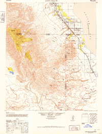
1952 Map of Agua Dulce
USGS Topo · Published 1952About this map
Oasis and its surrounding desert valley landscape are documented here at a transitional moment of post-war development in the early 1950s. The map illustrates the harsh contrast between the arid Santa Rosa Mtns and the low-lying Coachella Valley, where life clustered around water sources and transportation routes. Infrastructure for early travelers is evident at the Oasis Maintenance Sta and the Salton Sea Service Sta, while local industry and education are represented by the Flemming Saw Mill and Oasis Sch. This region, crossing the boundaries of Riverside, San Diego, and Imperial Counties, relied heavily on natural water features such as Seventeen Palms Spring and Fish Springs. The intricate network of washes, including Arroyo Salado and Gravel Wash, reveals the hydraulic history of the desert floor leading toward the Salton Sea.
Find a feature on this map
28 named features on this map. Tap any name to fly to it.
Don’t see what you’re looking for? This feature index may not catch every label — zoom into the map to look around manually.
Map Details
Editions of this 1952 Agua Dulce Map
This is the sole edition of this map. No revisions or reprints were ever made.
Other maps of this area

1904 · Indio
USGS Topo · 1:125,000

1931 · Vallecito
USGS Topo · 1:125,000

1939 · Borrego
USGS Topo · 1:62,500

1940 · Kane Spring
USGS Topo · 1:62,500

1940 · Cottonwood Spring
USGS Topo · 1:62,500

1940 · Durmid
USGS Topo · 1:62,500

1941 · Toro Peak
USGS Topo · 1:62,500

1941 · Clark Lake
USGS Topo · 1:62,500

1941 · Coachella
USGS Topo · 1:62,500

1942 · Barrel Spring
USGS Topo · 1:62,500