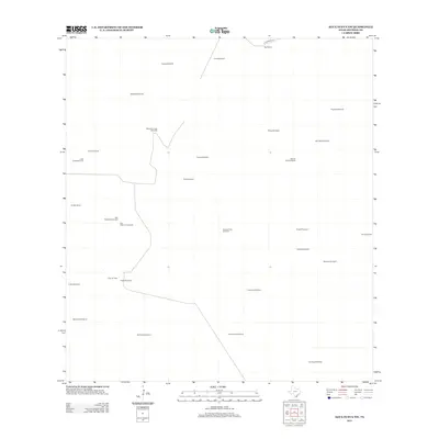
2012 Map of Agua Nueva NW
USGS Topo · Published 2012About this map
Venada Ranch and Weil Ranch represent the primary residential anchors in this corner of Jim Hogg County, reflecting the enduring ranching traditions of South Texas. The landscape is defined by its water infrastructure, with dozens of named wells like Buenos Aires Windmill, Agua Verde Windmill, and Santo Domingo Windmill distributed across the grid. These features highlight the necessity of reliable groundwater in a region where large-scale cattle operations dominate the land use.
Find a feature on this map
30 named features on this map. Tap any name to fly to it.
Don’t see what you’re looking for? This feature index may not catch every label — zoom into the map to look around manually.
Map Details
Editions of this 2012 Agua Nueva NW Map
This is the sole edition of this map. No revisions or reprints were ever made.
Other maps of this area

1938 · Agua Nueva
USGS Topo · 1:62,500

1938 · Cuevitas
USGS Topo · 1:62,500

1939 · Randado
USGS Topo · 1:62,500

1940 · Randado
USGS Topo · 1:62,500

1949 · Mc Allen
USGS Topo · 1:250,000

1954 · McAllen
USGS Topo · 1:250,000

1956 · Laredo
USGS Topo · 1:250,000

1957 · Mc Allen
USGS Topo · 1:250,000

1962 · McAllen
USGS Topo · 1:250,000
1972 · San Pablo Ranch
USGS Topo · 1:24,000