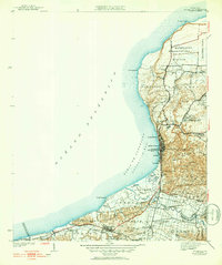
1942 Map of Aguadilla
USGS Topo · Published 1952About this map
Aguadilla and the northwestern coastline of Puerto Rico are defined by the American Railroad corridor, which connects several inland and coastal barrios during the mid-twentieth century. The landscape is a mix of agricultural and military importance, evidenced by the large Reservación Militar at Maleza Baja and industrial sites like Coloso. In the town of Aguadilla, social and civic landmarks such as the Iglesia, Parque de Colon, and the Acueducto are clearly mapped, while the surrounding hills include notable elevations like Cerro Vigia and Cerro San Jose. Smaller rail stops, including Desvio Camaceyes and Desvio Jimenez, suggest a period of active rail transport for both passengers and the local sugar economy. The drainage of the Rio Culebra and Rio Guayabo into the Aguadilla Bay illustrates the coastal hydrology before later urban expansion shifted these drainage patterns.
Find a feature on this map
65 named features on this map. Tap any name to fly to it.
Don’t see what you’re looking for? This feature index may not catch every label — zoom into the map to look around manually.
Map Details
Editions of this 1942 Aguadilla Map
5 editions found
Other maps of this area

1937 · Aguadilla
USGS Topo · 1:20,000

1937 · Moca
USGS Topo · 1:20,000

1938 · Alto Sano
USGS Topo · 1:20,000

1941 · Moca
USGS Topo · 1:30,000

1941 · Rincon
USGS Topo · 1:30,000

1941 · Rincon
USGS Topo · 1:30,000

1941 · Isabela
USGS Topo · 1:30,000

1942 · Moca
USGS Topo · 1:30,000

1942 · Central La Plata
USGS Topo · 1:30,000

1942 · Aguadilla
USGS Topo · 1:30,000