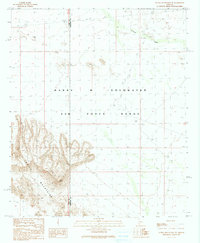
1990 Map of Aguila Mountains NE
USGS Topo · Published 1990About this map
The Aguila Mountains dominate the southwestern portion of this desert landscape, characterized by complex relief and drainage patterns. This 1990 provisional map records the intersection of the Yuma Co and Maricopa Co boundaries within the massive Barry M Goldwater Air Force Range. The map reflects a landscape primarily defined by military and topographic considerations rather than civilian settlement. To the northeast, the ephemeral Tenmile Wash cuts through the basin, part of a broader network of dry washes that define the drainage of the Gila River valley region. This survey is a snapshot of the Sonoran Desert under military jurisdiction, where the terrain is marked by landing strips and a sparse network of unimproved roads and trails used for range access.
Find a feature on this map
5 named features on this map. Tap any name to fly to it.
Don’t see what you’re looking for? This feature index may not catch every label — zoom into the map to look around manually.
Map Details
Editions of this 1990 Aguila Mountains NE Map
2 editions found
Other maps of this area

1927 · Aguila Mountains
USGS Topo · 1:48,000

1929 · Aztec
USGS Topo · 1:62,500

1930 · Aguila Mountains
USGS Topo · 1:62,500

1949 · Sentinel
USGS Topo · 1:62,500

1950 · Sentinel
USGS Topo · 1:62,500

1950 · Aztec
USGS Topo · 1:62,500

1953 · Ajo
USGS Topo · 1:250,000

1957 · Ajo
USGS Topo · 1:250,000

1958 · Ajo
USGS Topo · 1:250,000

1962 · Ajo
USGS Topo · 1:250,000