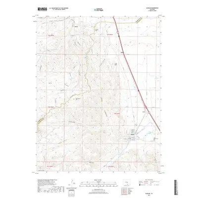
2019 Map of Aguilar
USGS Topo · Published 2019About this map
Aguilar sits at the eastern edge of a transition from the plains to the high country, where the Apishapa River and Boffego Ditch irrigate the lower elevations. The landscape is defined by its deep canyons and elevated flats, including Gonzales Canyon, Brodhead Canyon, and the sprawling Goat Ranch Flat. This 2019 survey reflects a territory where industrial and agricultural history is etched into the terrain, seen in the routes of Rugby Mine Rd and the proximity of established settlements like Rouse and Rugby. Local genealogy and community landmarks are anchored by the Saint Anthony Cem near the banks of the river. The topography climbs toward the west through Big Flat and Sawmill Flat, eventually reaching prominent heights like T V Hill and the distinctive formation of Rugby Rock. The county line between Huerfano Co and Las Animas Co cuts through the northern section, dividing these ranchlands and canyons.
Find a feature on this map
70 named features on this map. Tap any name to fly to it.
Don’t see what you’re looking for? This feature index may not catch every label — zoom into the map to look around manually.
Map Details
Editions of this 2019 Aguilar Map
This is the sole edition of this map. No revisions or reprints were ever made.
Other maps of this area

1891 · Walsenburg
USGS Topo · 1:125,000

1891 · Spanish Peaks
USGS Topo · 1:125,000

1893 · Spanish Peaks
USGS Topo · 1:125,000

1894 · Walsenburg
USGS Topo · 1:125,000

1895 · Spanish Peaks
USGS Topo · 1:125,000

1897 · Walsenburg
USGS Topo · 1:125,000

1897 · Spanish Peaks
USGS Topo · 1:125,000

1900 · Spanish Peaks
USGS Topo · 1:125,000

1900 · Walsenburg
USGS Topo · 1:125,000

1954 · Trinidad
USGS Topo · 1:250,000