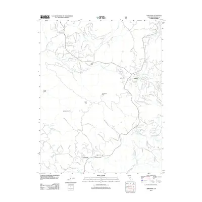
2012 Map of Ahwahnee
USGS Topo · Published 2012About this map
Oakhurst and Coarsegold anchor this central California survey, documenting the Sierra Nevada foothills during a period of modern residential expansion. The network of winding roads, such as Road 600 and Road 620, illustrates how contemporary housing has integrated into the complex terrain of Potter Ridge and Buckeye Mountain. The landscape is defined by the headwaters of the Fresno River, which flows through the historic site of Fresno Flats before continuing south. Local history is etched into the topography at Deadwood Peak and along the drainages of Coarse Gold Cr and China Cr. Further north, the settlement of Ahwahnee sits near the confluence of Peterson Cr and Miami Cr, while Yosemite Forks marks a significant junction for travelers heading toward the national park. The map meticulously records numerous local post offices and a dense grid of named residential lanes that trace the evolving community footprint in Madera County.
Find a feature on this map
106 named features on this map. Tap any name to fly to it.
Don’t see what you’re looking for? This feature index may not catch every label — zoom into the map to look around manually.
Map Details
Editions of this 2012 Ahwahnee Map
This is the sole edition of this map. No revisions or reprints were ever made.
Other maps of this area

1912 · Mariposa
USGS Topo · 1:125,000

1942 · Raymond
USGS Topo · 1:62,500

1942 · Millerton Lake
USGS Topo · 1:62,500

1944 · Raymond
USGS Topo · 1:62,500

1945 · Millerton Lake
USGS Topo · 1:62,500

1947 · Mariposa
USGS Topo · 1:250,000

1947 · Mariposa
USGS Topo · 1:62,500
1947 · Stumpfield Mtn.
USGS Topo · 1:24,000
1947 · Horsecamp Mountain
USGS Topo · 1:24,000
1948 · Stumpfield Mountain
USGS Topo · 1:24,000