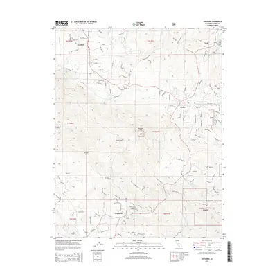
2015 Map of Ahwahnee
USGS Topo · Published 2015About this map
Oakhurst and Ahwahnee anchor this portion of the foothills where the Fresno River and its various forks descend from the high country. The landscape is defined by the intersection of early settlement roads like Road 600 and Raymond RD, which connect the communities of Coarsegold and Yosemite Forks. Extensive sections of the Sierra National Forest cover the eastern half of the map, encompassing landmarks such as Deadwood Peak and Thornberry Mtn. The terrain is marked by deep drainage systems, including French Gulch and Deadwood Gulch, which feed into the Coarse Gold Cr and Fine Gold Cr systems. This map shows the developed road network of the mid-2010s, including specific local names like Ellen Mine Rd and Tom Jones Rd, reflecting the modern residential sprawl into the foothills of the Sierra Nevada.
Find a feature on this map
46 named features on this map. Tap any name to fly to it.
Don’t see what you’re looking for? This feature index may not catch every label — zoom into the map to look around manually.
Map Details
Editions of this 2015 Ahwahnee Map
This is the sole edition of this map. No revisions or reprints were ever made.
Other maps of this area

1912 · Mariposa
USGS Topo · 1:125,000

1942 · Raymond
USGS Topo · 1:62,500

1942 · Millerton Lake
USGS Topo · 1:62,500

1944 · Raymond
USGS Topo · 1:62,500

1945 · Millerton Lake
USGS Topo · 1:62,500

1947 · Mariposa
USGS Topo · 1:250,000

1947 · Mariposa
USGS Topo · 1:62,500
1947 · Stumpfield Mtn.
USGS Topo · 1:24,000
1947 · Horsecamp Mountain
USGS Topo · 1:24,000
1948 · Stumpfield Mountain
USGS Topo · 1:24,000