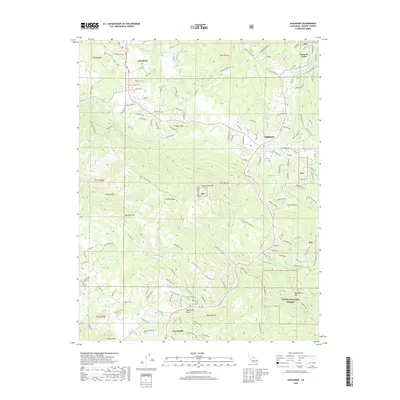
2018 Map of Ahwahnee
USGS Topo · Published 2018About this map
Oakhurst and Ahwahnee sit at the edge of the Sierra National Forest, where the lower foothills rise into the central California mountains. The landscape is defined by the Fresno River and its various tributaries, including Nelder Cr and Lewis Fork, which carve through the high ground of Buckeye Mtn and Potter Ridge. This 2018 survey reveals the persistent imprint of historical mining and timber management, specifically around the Texas Flat Mines near Coarsegold and the network of fire roads. Evidence of early settlement patterns remains visible in the winding routes of Rd 621 and Miami Highlands Dr, while the Deadwood Lookout stands as a sentinel over the surrounding terrain. The transition from valley floor to forest is marked by scattered gulches like French Gulch and the prominent heights of Thornberry Mtn.
Find a feature on this map
145 named features on this map. Tap any name to fly to it.
Don’t see what you’re looking for? This feature index may not catch every label — zoom into the map to look around manually.
Map Details
Editions of this 2018 Ahwahnee Map
This is the sole edition of this map. No revisions or reprints were ever made.
Other maps of this area

1912 · Mariposa
USGS Topo · 1:125,000

1942 · Raymond
USGS Topo · 1:62,500

1942 · Millerton Lake
USGS Topo · 1:62,500

1944 · Raymond
USGS Topo · 1:62,500

1945 · Millerton Lake
USGS Topo · 1:62,500

1947 · Mariposa
USGS Topo · 1:250,000

1947 · Mariposa
USGS Topo · 1:62,500
1947 · Stumpfield Mtn.
USGS Topo · 1:24,000
1947 · Horsecamp Mountain
USGS Topo · 1:24,000
1948 · Stumpfield Mountain
USGS Topo · 1:24,000