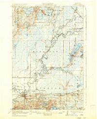
1915 Map of Aitkin
USGS Topo · Published 1937About this map
The Mississippi River snakes through the heart of this Aitkin County landscape, exhibiting a complex system of oxbows and meanders that defined the local geography before modern channelization. The settlement of Aitkin serves as the primary hub, situated at the junction of the Minneapolis St Paul and Sault Ste Marie railroad and the river. This rail network, including the Northern Pacific line, was instrumental in connecting the timber and agricultural lands of Morrison and Spencer townships to wider markets.
Find a feature on this map
51 named features on this map. Tap any name to fly to it.
Don’t see what you’re looking for? This feature index may not catch every label — zoom into the map to look around manually.
Map Details
Editions of this 1915 Aitkin Map
4 editions found
Other maps of this area

1912 · Deerwood
USGS Topo · 1:62,500

1913 · Cuyuna
USGS Topo · 1:62,500

1914 · Deerwood
USGS Topo · 1:62,500

1914 · Aitkin
USGS Topo · 1:62,500

1915 · Aitkin
USGS Topo · 1:62,500

1915 · Cuyuna
USGS Topo · 1:62,500

1916 · Wealthwood
USGS Topo · 1:62,500

1953 · Duluth
USGS Topo · 1:250,000

1958 · Duluth
USGS Topo · 1:250,000

1969 · Thor
USGS Topo · 1:24,000