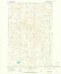
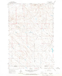
1963 Map of Akers Ranch
USGS Topo · Published 1966About this map
Akers Ranch serves as the central focal point in this remote corner of Musselshell County, where the high plains landscape is defined by the drainage patterns of Howard Coulee and North Willow Creek. The 1963 field check reveals a landscape transitioning between natural prairie and managed ranch land, evidenced by the presence of Arkansas Spring and multiple water management features. Of particular interest to those studying local land use and infrastructure are the noted Flowing Well and Drill Hole locations, alongside specific reservoir data such as Spillway Elev 2980 and Spillway Elev 2992. These labels indicate a reliance on scarce water sources in a terrain where Sand Creek and other intermittent waterways provide the primary topographic relief.
Find a feature on this map
9 named features on this map. Tap any name to fly to it.
Don’t see what you’re looking for? This feature index may not catch every label — zoom into the map to look around manually.
Map Details
Editions of this 1963 Akers Ranch Map
This is the sole edition of this map. No revisions or reprints were ever made.
Other maps of this area

1954 · Forsyth
USGS Topo · 1:250,000

1954 · Roundup
USGS Topo · 1:250,000

1957 · Forsyth
USGS Topo · 1:250,000

1958 · Roundup
USGS Topo · 1:250,000

1958 · Forsyth
USGS Topo · 1:250,000
1962 · Queens Point
USGS Topo · 1:24,000
1962 · Maxwell Ranch
USGS Topo · 1:24,000
1962 · Melstone NW
USGS Topo · 1:24,000
1963 · Kelley
USGS Topo · 1:24,000
1963 · Musselshell
USGS Topo · 1:24,000