
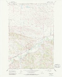
1963 Map of Musselshell
USGS Topo · Published 1966About this map
The Musselshell River winds through a landscape of high prairie and coulees, defining the geography of the central Montana plains in the early 1960s. The settlement of Musselshell serves as the focal point, situated along the Chicago Milwaukee St Paul and Pacific railroad line. This rail-and-river corridor supported a agricultural and industrial network, including storage bins, a Gaging Sta, and an Athletic Field. Further west, the locale of Goffena marks a distinct point of interest for local historians.
Find a feature on this map
23 named features on this map. Tap any name to fly to it.
Don’t see what you’re looking for? This feature index may not catch every label — zoom into the map to look around manually.
Map Details
Editions of this 1963 Musselshell Map
2 editions found
Other maps of this area

1954 · Forsyth
USGS Topo · 1:250,000

1954 · Roundup
USGS Topo · 1:250,000

1957 · Forsyth
USGS Topo · 1:250,000

1958 · Roundup
USGS Topo · 1:250,000

1958 · Forsyth
USGS Topo · 1:250,000

1962 · Queens Point
USGS Topo · 1:24,000

1962 · Melstone NW
USGS Topo · 1:24,000
1963 · Akers Ranch
USGS Topo · 1:24,000

1963 · Musselshell NW
USGS Topo · 1:24,000

1963 · Delphia
USGS Topo · 1:24,000