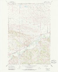
1963 Map of Musselshell
USGS Topo · Published 1985About this map
The Musselshell River winds through this central Montana landscape, serving as the lifeblood for a region defined by its diverse resource extraction and early transport networks. In the settlement of Musselshell, the infrastructure reflects a small but active community, complete with an Athletic Field, Storage Bins, and a Gaging Sta monitoring the river's flow. The industrial character of the era is evident in the presence of the Melstone Oil Field to the north and various excavations like the Gravel Pit and Mine scattered near the water.
Find a feature on this map
21 named features on this map. Tap any name to fly to it.
Don’t see what you’re looking for? This feature index may not catch every label — zoom into the map to look around manually.
Map Details
Editions of this 1963 Musselshell Map
2 editions found
Other maps of this area

1954 · Forsyth
USGS Topo · 1:250,000

1954 · Roundup
USGS Topo · 1:250,000

1957 · Forsyth
USGS Topo · 1:250,000

1958 · Roundup
USGS Topo · 1:250,000

1958 · Forsyth
USGS Topo · 1:250,000

1962 · Queens Point
USGS Topo · 1:24,000

1962 · Melstone NW
USGS Topo · 1:24,000

1963 · Musselshell
USGS Topo · 1:24,000
1963 · Akers Ranch
USGS Topo · 1:24,000

1963 · Musselshell NW
USGS Topo · 1:24,000