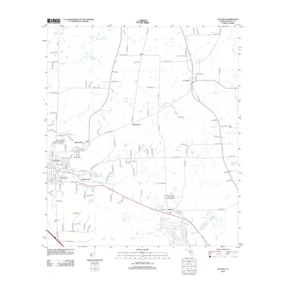
2012 Map of Alachua
USGS Topo · Published 2012About this map
Alachua and its surrounding agricultural districts are captured here during a period of steady growth north of Gainesville. The map details the transition from the concentrated downtown area of Alachua to the smaller outlying settlements of Hague, La Crosse, and the historic site of Newnansville. This former county seat, once a vital frontier outpost, is marked here primarily by the Newnansville Cem. The landscape is defined by its agricultural roots, evidenced by the University of Florida Agricultural Experimental Farm and the La Crosse Forestry Site. Significant water features like Sweet Water Lake and the winding Turkey Cr drain the area, while the road network includes the historic Old Bellamy Rd, tracing a route that dates back to the territorial period of Florida history.
Find a feature on this map
66 named features on this map. Tap any name to fly to it.
Don’t see what you’re looking for? This feature index may not catch every label — zoom into the map to look around manually.
Map Details
Editions of this 2012 Alachua Map
This is the sole edition of this map. No revisions or reprints were ever made.
Other maps of this area

1890 · Arredondo
USGS Topo · 1:62,500

1892 · Arredondo
USGS Topo · 1:62,500

1894 · Arredondo
USGS Topo · 1:62,500

1954 · Gainesville
USGS Topo · 1:250,000

1958 · Gainesville
USGS Topo · 1:250,000

1959 · Gainesville
USGS Topo · 1:250,000

1962 · High Springs
USGS Topo · 1:24,000

1962 · Mikesville
USGS Topo · 1:24,000
1966 · Worthington Springs
USGS Topo · 1:24,000

1966 · Gainesville West
USGS Topo · 1:24,000