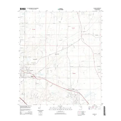
2015 Map of Alachua
USGS Topo · Published 2015About this map
Alachua serves as the focal point of this North Florida landscape, where the agricultural legacy of Alachua County is written across a grid of rural roads and established settlements. The historic site of Newnansville, once a prominent county seat, is preserved here alongside the Newnansville Cem, reflecting the early pioneer era before the railroad shifted the local economy toward the modern town center. The terrain is defined by its unique karst topography, featuring several significant water bodies such as Burnetts Lake, Sweet Water Lake, and Prairie Lake, as well as the flow of Mill Cr and Rocky Cr. To the northeast and southeast, the smaller communities of La Crosse and Hague mark the limits of this survey, connected by a network of state and local routes that have replaced older paths like Old Bellamy Rd. Numerous burial sites, including Antioch Cem and Old Thomas Cem, offer vital locations for genealogical research.
Find a feature on this map
112 named features on this map. Tap any name to fly to it.
Don’t see what you’re looking for? This feature index may not catch every label — zoom into the map to look around manually.
Map Details
Editions of this 2015 Alachua Map
This is the sole edition of this map. No revisions or reprints were ever made.
Other maps of this area

1890 · Arredondo
USGS Topo · 1:62,500

1892 · Arredondo
USGS Topo · 1:62,500

1894 · Arredondo
USGS Topo · 1:62,500

1954 · Gainesville
USGS Topo · 1:250,000

1958 · Gainesville
USGS Topo · 1:250,000

1959 · Gainesville
USGS Topo · 1:250,000

1962 · High Springs
USGS Topo · 1:24,000

1962 · Mikesville
USGS Topo · 1:24,000
1966 · Worthington Springs
USGS Topo · 1:24,000

1966 · Gainesville West
USGS Topo · 1:24,000