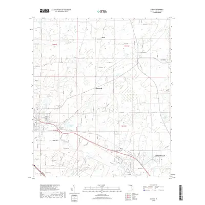
2018 Map of Alachua
USGS Topo · Published 2018About this map
Alachua serves as a primary hub in this north Florida landscape, where the agricultural tradition of the late 2010s meets the growing outskirts of Gainesville. The map captures a transition from the rolling fields near La Crosse and Hasan to the low-lying wetlands of Sanchez Prairie. Notable for genealogists and local historians, several burial sites are documented across the terrain, including the Newnansville Cem, Hague Cem, and Antioch Cem. Water features such as Burnetts Lake and Sweet Water Lake define the hydrology of the area. A network of country roads, including the named Old Bellamy Rd, traces old routes through settlements like Hainesworth and Hague, offering a clear view of the rural and suburban intersection in Alachua County.
Find a feature on this map
62 named features on this map. Tap any name to fly to it.
Don’t see what you’re looking for? This feature index may not catch every label — zoom into the map to look around manually.
Map Details
Editions of this 2018 Alachua Map
This is the sole edition of this map. No revisions or reprints were ever made.
Other maps of this area

1890 · Arredondo
USGS Topo · 1:62,500

1892 · Arredondo
USGS Topo · 1:62,500

1894 · Arredondo
USGS Topo · 1:62,500

1954 · Gainesville
USGS Topo · 1:250,000

1958 · Gainesville
USGS Topo · 1:250,000

1959 · Gainesville
USGS Topo · 1:250,000

1962 · High Springs
USGS Topo · 1:24,000

1962 · Mikesville
USGS Topo · 1:24,000
1966 · Worthington Springs
USGS Topo · 1:24,000

1966 · Gainesville West
USGS Topo · 1:24,000