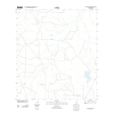
2013 Map of Alamito Creek
USGS Topo · Published 2013About this map
Alamito Creek and its many tributaries define the drainage patterns of this Webb County landscape, where ranching and water management are the primary features. The terrain is marked by a series of engineered water bodies, including Nicholson Lake, Abbott and Clapp Lake, and the Colwell Lake Dam. These reservoirs, along with the Nicholson Ranch Lake Number 2, suggest a focus on livestock and land management in this arid portion of South Texas. The most significant historical landmark is the Becerra Cem in the northwest, situated near the banks of Becerra Creek. Local transportation relies on a network of routes such as Becerras Rd and Callaghan Rd, which connect the scattered ranch properties and water crossings across the winding courses of Salado Creek and Gato Creek.
Find a feature on this map
14 named features on this map. Tap any name to fly to it.
Don’t see what you’re looking for? This feature index may not catch every label — zoom into the map to look around manually.
Map Details
Editions of this 2013 Alamito Creek Map
This is the sole edition of this map. No revisions or reprints were ever made.
Other maps of this area

1937 · Aguilete Creek
USGS Topo · 1:62,500

1956 · Becerra
USGS Topo · 1:62,500

1956 · Las Mujeres
USGS Topo · 1:62,500

1956 · Laredo
USGS Topo · 1:250,000

1968 · Mills Bennett NW
USGS Topo · 1:24,000
1973 · Biel Lake North
USGS Topo · 1:24,000
1974 · Biel Lake South
USGS Topo · 1:24,000
1980 · Alamito Creek
USGS Topo · 1:24,000
1980 · Piedra Parada Ranch
USGS Topo · 1:24,000
1980 · Piedra Parada Tank
USGS Topo · 1:24,000